Discover the northern stretch of the Wales Coast Path in the counties of Conwy and Denbighshire – a scenic route packed with wildlife, seaside towns, and nature reserves.
What to Expect
This itinerary breaks the route into six day-long sections, each starting from a central base. Some sections are longer due to limited accommodation, and while parts follow the National Cycle Network (NCN), others are footpath-only. This stretch of the path is very close to some amazing nature reserves providing the ideal opportunity to get closer to nature and to the coast.
Route Highlights
- Gronant Dunes: A Site of Special Scientific Interest (SSSI) and a breeding site for little tern and natterjack toad site.
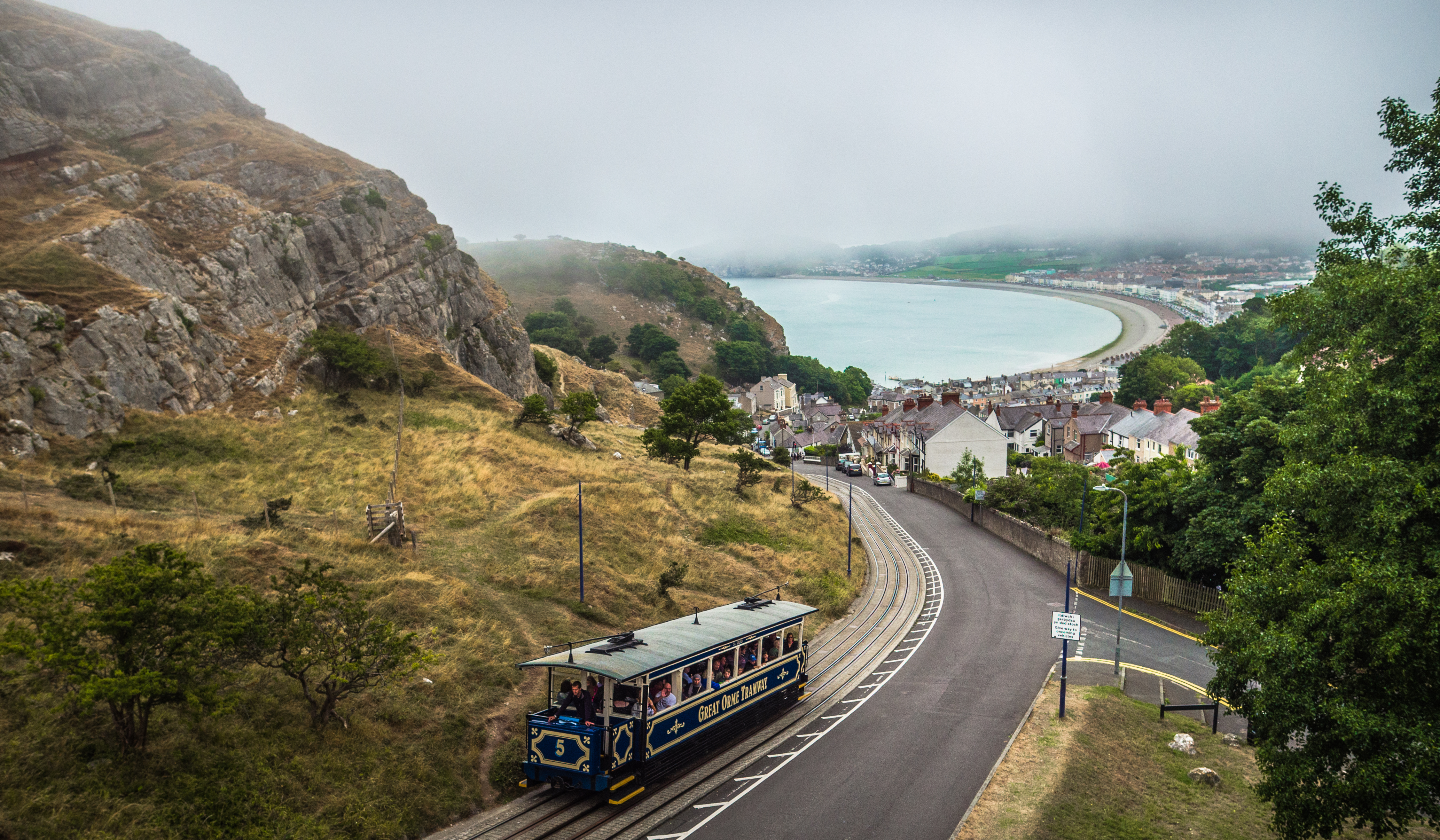
- Great Orme Country Park: A SSSI, Special Area of Conservation (SAC) and a Heritage Coast. There is a one way toll road around the Great Orme. The Great Orme Tramway is accessible for folding manual wheelchairs and pushchairs. You'll enjoy great views from below and from the top of this iconic landmark.
- RSPB Conwy: A nature reserve haven for waders and water birds, especially during the autumn and winter from August to March. Go to RSPB Conwy for more information
- Morfa Madryn Nature Reserve: A local Nature Reserve with great opportunities for bird and dragonfly spotting.
Start Points
There are various start points along this section which can be accessed along the coast using public transport.
Route Summary
There are six routes where you go out and come back the same way. If you want to go that bit further, these sections are designed so that you can travel as much as 41.5 miles/67.5 kilometres in one direction.
- Route 1: From Prestatyn and turn back at Gronant Dunes. This is a pleasant 4 miles/7 kilometres journey with coastal views and plenty of nature to spot along the way.
- Route 2: From Prestatyn for 4 miles/7 kilometres walk to Rhyl. You’ll experience wildlife and coastal views, with the chance to stop off at a café or two.
- Route 3: Start at Rhyl and walk 10 miles/17 kilometres to Colwyn Bay. It’s a great way to enjoy the coast, and enjoy a cuppa in the fresh air.
- Route 4: Start at Colwyn Bay and walk 6 miles/9 kilometres to Llandudno. Enjoy the vibrant seafronts of Colwyn Bay and Rhos on Sea.
- Route 5: Start at Llandudno and walk 8 miles/12.5 kilometres to Deganwy. Experience the Victorian resort of Llandudno and views of the Great Orme.
- Route 6: Start at Deganwy and walk 9.5 miles/15 kilometres to Llanfairfechan. Enjoy fantastic views across the Conwy Estuary of Conwy Castle and town, with an option of visiting Conwy RSPB Reserve.
Important Information for visitors
Please note we do not endorse or recommend any individual businesses over one or the other listed on this page. We strongly recommend checking with any businesses or service providers in advance to ensure they meet your needs as part of your planning.
Please note information relating to business names are correct at the time of publishing (October 2025). Please contact us to report any updates.
Public Toilets
More information about the toilets and the availability of RADAR key-operated accessible toilets along this section of the path can be found at public toilets in Conwy county or public toilets in Denbighshire
Public Transport
Plan your journey with Traveline Cymru, Wales' online journey planner to see which modes of transport is available in an area. Keep up to date with timetables and find out more about accessible transport in Wales. Specific details about the accessibiity of train stations on some of the routes are noted below.
Good to Know
The entire Wales Coast Path is mapped onto Google Street View, where you can see the route and decide whether it's suitable for you and your equipment.
Route 1: Prestatyn to Gronant Dunes, Denbighshire
Enjoy coastal views and wildlife as you walk from Prestatyn to Gronant Dunes in Denbighshire. This route includes boardwalks and sandy paths, with plenty of nature to spot along the way. Prestatyn Gutter and golf course are great places for birdwatching –remember to bring your binoculars. Gronant Dunes is a Site of Special Scientific Interest and home to little terns and natterjack toads.
- Start Point: Start from The Beaches Hotel, Prestatyn. Other options include Prestatyn train station, local bus stops, or car parks at Nova Leisure Centre or Barkby Beach. For a shorter walk, use the public car park with Blue Badge spaces on Shore Road, Gronant.
- Distance: 4 miles /7 kilometres
- Surface: The path surface is made up of footpaths, boardwalks, and sandy areas which may be difficult for equipment with non off road tyres.
- Slopes: There are some steep gradients on the dunes of up to 8 percent
- Elevation gain: 100 feet/20 metres
- Path width: Some sections of the path are narrower than 1.2 metres
- Potential barriers: Sand may build up on paths and boardwalks particularly towards Gronant Dunes.
- Facilities: Parking is available at The Beaches Hotel, Nova Leisure Centre, Barkby Beach, and Shore Road (Blue Badge spaces).
Route 2: Prestatyn to Rhyl, Denbighshire
The Wales Coast Path from Prestatyn to Rhyl gives varied opportunities for seeing wildlife and coastal views from boardwalks and promenades with the chance to stop off at a café or two on the way. There are mostly flat and offers great views along the route.
- Start point: The Beaches Hotel, Prestatyn. Alternative starting points could include Prestatyn train station, local bus stops, or one of the car parks at Nova Leisure Centre or Barkby Beach.
- Distance: Approximately 4 miles/7 kilometres
- Surface: There are sealed surfaces with some areas of sand drifting from the dunes onto the path. Sealed surfaces and shallow gradients.
- Slopes: There are shallow gradients with no steep inclines.
- Elevation gain: 115 feet/35 metres
- Potential barriers: Sand may build up on paths and boardwalks
- Facilities: Parking is available at The Beaches Hotel, Nova Leisure Centre, Barkby Beach, and Shore Road (Blue Badge spaces).
Route 3: Rhyl to Colwyn Bay, Conwy
The Wales Coast Path between Rhyl and Colwyn Bay is more undulating with some parts of the path becoming sand blown so some people may need assistance on these sections. The path goes very close to the beach at points and the views are spectacular.
Mostly flat and offers great views along the route. At Colwyn Bay the route passes under the train line and A55 to continue a short distance along the B5113 to reach the Travelodge, giving a stopover option.
For those wanting to continue to Llandudno without staying in Colwyn Bay there are accessible toilets and cafés along the promenade such as at Parisella’s ice cream parlour.
- Start point: The Premier Inn Rhyl Seafront. Alternative starting points might include Rhyl train station, local bus stops, or other nearby accommodation.
- Distance: Approximately 10 miles/17 kilometres
- Surface: There are sealed surfaces along the path, though some sections may have sand accumulation. In places, deep sand may pose a barrier, making the path impassable for some mobility equipment.
- Slopes: Be aware of steep inclines in places, especially between Pensarn and Colwyn Bay, with some sections as steep as 10 percent.
- Elevation gain: 416 feet/127 metres. There are steep gradients between Pensarn and Colwyn Bay.
- Potential barriers: At grid reference SH 99281 80985, deep sand deposits on the path make it impassable for some mobility equipment and non-standard cycles. Diversions are possible via the A548 and NCN 5 cycle route.
- Public transport: Abergele and Pensarn train station is just over 4 miles/7 kilometres into the route. You can catch the train back to Rhyl or to Colwyn Bay from this point. Colwyn Bay train station has step-free access to all platforms for onward journeys.
- Facilities: Parking is available at Premier Inn Rhyl Seafront and other nearby locations. Public RADAR key-operated toilets are available including Pensarn and Colwyn Bay.
Route 4: Colwyn Bay to Llandudno, Conwy
The route starts at the Travelodge Colwyn Bay and follows the Wales Coast Path to Llandudno, passing through the seafronts of Colwyn Bay, Rhos on Sea, Penrhyn Bay and next to the Little Orme area. There are plenty of places to stop to eat and drink on the vibrant seafronts of Colwyn Bay and Rhos on Sea.
This section ends in the elegant Victorian resort of Llandudno, where there is a variety of places to eat, drink and stay. There are some steep inclines and rough patches, particularly near the Little Orme area. The path can be narrow and sandy in some sections.
- Start point: Travelodge Colwyn Bay. Alternative starting points include Colwyn Bay train station, local bus stops, or nearby accommodation
- Distance: Approximately 6 miles/9 kilometres
- Surface: Sealed surfaces with some rough or narrow sections, particularly near Little Orme and after the Dale Road car park
- Slopes: Some steep sections, ranging between 14 and 16 percent around Penrhyn Bay and Little Orme
- Elevation gain: 370 feet/113 meters
- Potential barriers: The route encounters a flight of steps at Little Orme, which is not accessible for people using mobility equipment or non-standard cycles. Additionally, some parts of the path near Dale Road car park are rough, narrow, and sandy, making them impassable for mobility equipment. A diversion route is available along the NCN 5 cycleway or the B5115 road.
- Facilities: Parking is available at Travelodge Colwyn Bay and nearby locations such as Dale Road.
Route 5: Llandudno to Deganwy, Conwy
The elegant Victorian resort of Llandudno is situated at the base of the limestone outcrop of the Great Orme, an ideal birdwatching site. Llandudno is an ideal base for exploring other sections on this part of the Wales Coast Path if you prefer to stay in one place.
Deganwy, Conwy and Llandudno would make good bases for people to explore RSPB Conwy. An additional loop around the Great Orme, starting from Llandudno promenade and following the Wales Coast Path along Marine Drive towards Deganwy. This section includes a climb up the Great Orme, which can be done by car or tram.
- Start point: Llandudno - Central location on the promenade (specific hotels include Cae Mor, The Imperial, and St. George’s Hotel). Alternative starting points are Llandudno train station, local bus stops, or nearby accommodation
- Distance: Approximately 8 miles/12.5 kilometres
- Surface: There are sealed surfaces, but some sections have steep gradients, particularly on Marine Drive. The path becomes rough, narrow, and sandy at Dale Road car park
- Slopes: Steep inclines of 16 percent, particularly if taking the route arounf the Great Orme
- Elevation gain: approximately 200 metres/660 feet
- Potential barriers: The path between Dale Road car park and Deganwy becomes impassable for most mobility equipment and non-standard cycles. Some people may prefer to stay on the pavement on the A546 for the final part of the route to the Quay Hotel. There are some very steep inclines, particularly around Marine Drive and up the Great Orme. The steep inclines, especially on the Great Orme, make this route challenging.
- Facilities: Parking is available at The Quay Hotel, Deganwy, and other locations, such as Dale Road.
Route 6: Deganwy to Llanfairfechan, Conwy
This section gives fantastic views across the Conwy Estuary of Conwy Castle and town with an option of visiting Conwy RSPB Reserve – a detour of approximately 1 mile from Conwy Cob, a part of the Wales Coast Path. This strip of land separates the Conwy bridge and the opposite bank of the estuary at Llandudno Junction.
From Conwy town the route goes along the Conwy estuary via the marine and onto the NCN 5 via Morfa Conwy. The route follows the NCN route number 5 cycle path between the coast and the A55 to Llanfairfechan. Note that the route between Morfa Conwy and Llanfairfechan follows the busy A55 and can therefore be noisy. The views however make this a rewarding section.
Route highlights include Conwy RSPB Reserve. Llanfairfechan seafront has café’s, toilets and access to a nature reserve about 2 kilometres west with bird hides and excellent views. Approximately 1.5 miles west of Llanfairfechan on the Wales Coast Path is Morfa Madryn Nature Reserve with a scenic beach and bird hides with ramped access.
- Start point: The Quay Hotel and Spa, Deganwy (alternative starting points include Deganwy train station or local bus stops).
- Distance: Approximately 9.5 miles/15 kilometres
- Surface: There are sealed surfaces. The path includes access ramps and some challenging terrain, especially near the A55 crossings. The path also passes through sand dunes in some places.
- Slopes: There are steep inclines at several access ramps, particularly when crossing the A55. The inclines are generally sharp, which may be difficult for some mobility equipment.
- Elevation gain: approximately 500 feet/150 metres
- Potential barriers: The path narrows in some areas and may become difficult to navigate, particularly in the sand dunes and near steep access ramps. Access ramps and sharp corners around A55 crossings may present barriers for some users. Sand dunes in areas like Conwy Morfa make sections impassable for non-standard cycles and mobility equipment.
- After Morfa Conwy, following the NCN 5 route may be necessary to bypass impassable sections of the Wales Coast Path. The NCN 5 also provides a route to Bangor, a compact university city.
- At the Deganwy end of the Wales Coast Path, the path runs through sand dunes and would be impassable for most mobility equipment and non-standard cycles.
- Public Transport: There is the option to catch a train east bound from Llanfairfechan train station but the west-bound platform to Bangor does not have step-free access. Bangor train station has step-free access to all platforms.
- Facilities: Parking is available at The Quay Hotel, Deganwy, and additional spaces along the route at various locations such as Llanfairfechan. Public RADAR Key-operated toilets available at Deganwy, Llanfairfechan, and Conwy.
Accommodation and Camping
There are a number of campsites and suitable hotel accommodation in the area so that people can travel between overnight stays.
Prestatyn
The Beaches Hotel has suitable accommodation including ground floor rooms. The rooms have some grab bars next to the WC and in the shower cubicle. Some people who can walk a little might find this accommodation suitable.
Rhyl
Premier Inn Rhyl Seafront and Travelodge Rhyl Seafront are options for suitable accommodation.
Colwyn Bay
Travelodge Colwyn Bay is an option for suitable accommodation.
Llandudno
Has the best options for suitable accommodation and would be a good place to stay if a central location was preferred. Hotels that have facilities for disabled people include Cae Mor Hotel, The Imperial Hotel and St. George’s Hotel. These hotels have walk in showers but no wall fixed shower seat-portable free-standing seats are available on request. There are also hotel chains such as Travel Inn and Travelodge, which have adapted rooms with en-suite bathrooms.
Deganwy
The Quay Hotel and Spa has different room options with ensuite bathrooms that have been adapted for disabled people including wet-floor shower rooms and wall-mounted shower seats.
Conwy
YHA Conwy has one adapted room and their Access Statement describes the room as: “One accessible en-suite room that sleeps up to 3 people. It includes a single high-sleeper bunk with a double bed underneath. The en-suite bathroom includes a toilet with grab rails and right-handed transfer. The shower has a fold-down shower chair but there are no grabrails and it is not accessible to modern standards.” Visit YHA Accessible hostels
Llanfairfechan
This is the final destination for the route but does not have accessible accommodation. The train station has an accessible platform for people travelling eastbound and the train service could be used to return to the start of the route. The westbound platform for Bangor is not accessible.
Bangor
The route has only been checked to Llanfairfechan. There is the NCN 5 cycle route, or the number 5 bus could be used to reach Bangor. There are 2 rooms (single and double) with adapted ensuite bathrooms at the Bangor Management Centre.
There are more online resources to help you look for accommodation along the path. Search the official sites for Premier Inn and Travelodge
Transportation
The north Wales coastline is well served by buses and trains with some accessible wheelchair taxis available. Use Traveline Cymru to plan your journey, find up to date timetables and a map of bus and train stations which you can see on Google Street View.
Bus Routes
There are several bus services that run along different parts of the Wales Coast Path between Prestatyn and Bangor.
- The number 11 service runs between Prestatyn and Rhyl
- The number 12/X12 service runs between Rhyl and Llandudno.
- The number 13 runs between Prestatyn and Llandudno but does not stop at Rhyl.
- The number 5 bus serves the route from Llandudno and Bangor, stopping at Conwy and Llanfairfechan.
Trains
Wheelchair Accessible Taxis
There are a few taxis which can accommodate wheelchairs.
- Busy Bee Taxis cover Prestatyn, Rhyl and Kinmel Bay and wheelchair accessible vehicles.
- Castle Cabs in Conwy have one wheelchair accessible vehicle.
- Uber Wheelchair Accessible Vehicles may also be available in Bangor and other areas.
Further information
The following websites have more travel information and inspiration to help you make the most of your time on the path.
- The official Visit Wales website to get great holiday ideas in Wales, family breaks, weekend getaways and walking holidays.
- Go North Wales is the official North Wales tourism website. North Wales is an adventure playground with activities to keep most adrenaline junkies happy.
- The official Visit Conwy tourism website has plenty more travel inspiration on where to stay and things to do, like amazing beaches, the Llandudno cable cars and pier, excellent theatres, a fascinating zoo, first class golf courses, mighty big mountains and castles.